KeyTERRA-FIRMA
KeyTERRA-FIRMA Software
Whether you’re creating topographic surveys, designing roads, or planning large-scale site developments, KeyTERRA-FIRMA equips you with the tools you need to bring your visions to life. You’ll benefit from advanced capabilities like 3D terrain modelling, volume calculations, cross and long section visualisation, and so much more.
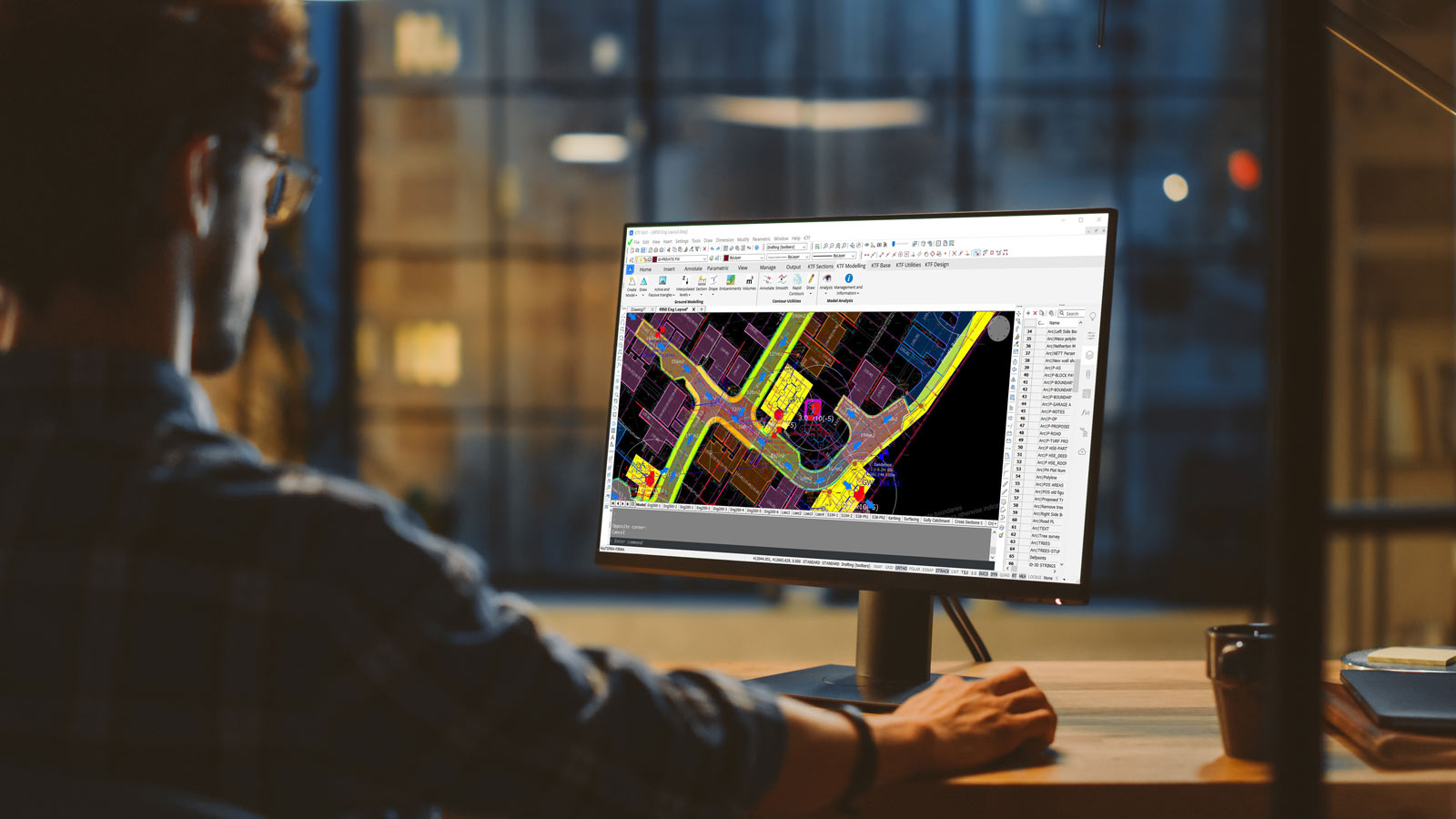
KeyTERRA-FIRMA is a powerful, easy-to-use application for AutoCAD® and BricsCAD®. Designed for use in Civil, Infrastructure, Land Survey, Environmental and Landscape applications to help simplify complex calculations and improve workflows and productivity.
“Instinctive and straightforward to learn…excellent support and development”
Overall, an excellent design tool written by a very end-user focused company who provide excellent support and development for their product
Taylor Wimpey
“Key TERRA-FIRMA is a very easy to use but effective tool…I highly recommend this product”
It has allowed a person with no surveying or technical drawing abilities to down load survey data and manipulate it on a drawing platform.
SiEnergy
Why choose KeyTERRA-FIRMA?
Designed by engineers for engineers, KeyTERRA-FIRMA offers a comprehensive suite of tools aimed at simplifying and enhancing all aspects of your civil engineering projects. From the initial surveying process to detailed geospatial analysis and site design, our software provides the capabilities you need to optimize your projects, reduce costs, and achieve better results.
The system is simple to use, extremely flexible and suitable for a wide range of objectives. In addition to typical development and road design projects, KeyTERRA-FIRMA has been used in Coastal Erosion studies, Hydrographic Surveys, Landfill Projects, Quarries and Airfield approach studies.
KeyTERRA-FIRMA Base
Who It’s For?
Designed for Land Surveyors who need high levels of precision, accuracy and efficiency in creating comprehensive topgraphic plans. KeyTERRA-FIRMA Base imports coordinate data from a wide range of Dataloggers, Total Stations and GPS equipment to create topographic surveys at the click of a button.
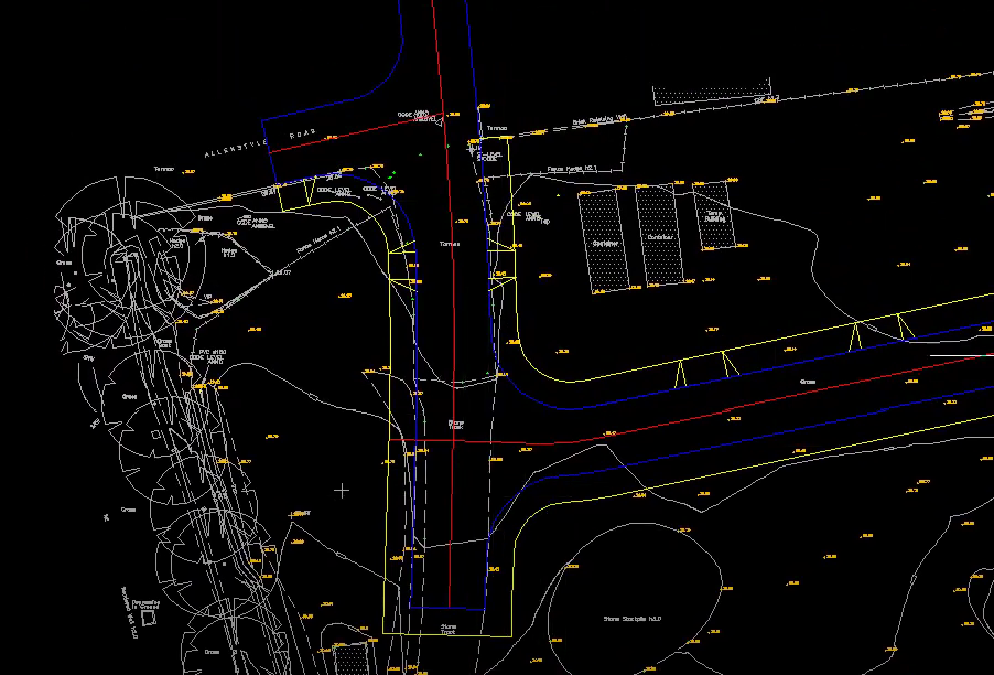
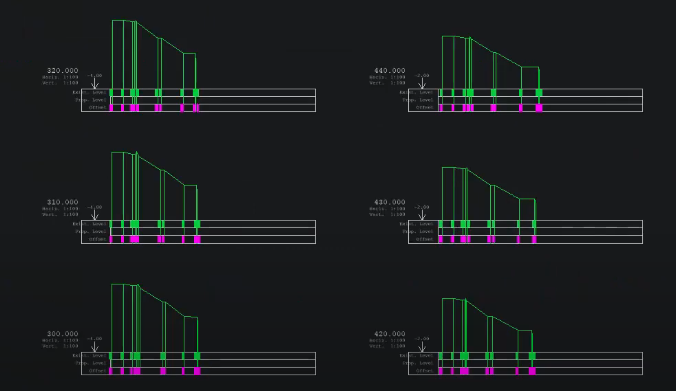
Excellence in Cross Sections and Long Sections
KeyTERRA-FIRMA Base excels in generating detailed cross-sections and long sections, which are crucial for understanding the terrain and planning infrastructure projects. This strength allows surveyors to visualize and analyze the lay of the land accurately, providing invaluable insights for decision-making and design.
Seamless Integration with BricsCAD Pro Civil
KeyTERRA-FIRMA Base seamlessly integrates with BricsCAD Pro meaning you can carry out your workflow in the same, familiar .dwg environment. BricsCAD Civil is elevated to new levels with KeyTERRA-FIRMA Base where you can create TIN surfaces and ground models, transforming raw data into dynamic, three-dimensional representations of the physical site. Section functionality enhances the surveying workflow and elevates the level of detail and accuracy in the final output.
Enhance Your Surveying Workflow with KeyTERRA-FIRMA Base
Focusing on the essential needs of land surveyors, KeyTERRA-FIRMA Base is a solution that brings your topographic surveys to life with precision, efficiency, and clarity, all in standard .dwg format. KeyTERRA-FIRMA Base equips you with the power to capture the true essence of your site to send to designers in a compatible format, paving the way for successful projects.

KeyTERRA-FIRMA Mainstream
Who It’s For?
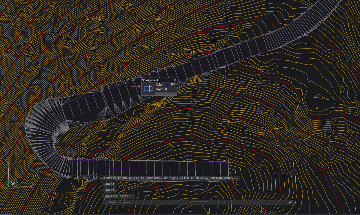
Designed for Civil Engineers, KeyTERRA-FIRMA Mainstream is at the heart of our software, where the existing site and design proposals are represented as surfaces created from 3D entities and displayed in a CAD drawing.
Horizontal and Vertical Alignment Designs combine with powerful 3D String functions in the 3D Site & Road Design module to make this the ideal tool for a variety of highway related projects whether simple or complex.
Advanced 3D Ground Modelling
At the heart of KeyTERRA-FIRMA Mainstream is its unparalleled capability in 3D ground modeling. This essential feature enables engineers to create accurate, detailed models of the terrain, forming the foundation upon which all project elements are built and analyzed.
Surfaces and Grading for Precision Engineering
The software’s sophisticated surfaces and grading functionalities allow for meticulous control over every aspect of the design. From the initial concept to the final grading plan, engineers have the tools at their fingertips to sculpt the landscape according to the project’s specifications, ensuring that every element is executed with the highest level of accuracy.
Comprehensive Analysis and Design Tools
Beyond ground modelling, KeyTERRA-FIRMA Mainstream excels in facilitating in-depth geospatial analysis and generating comprehensive mapping outputs. These tools are critical in understanding the nuances of the site, ensuring that every decision is informed, and every design is optimized for performance and sustainability.
KeyTERRA-FIRMA ZTV
Who It’s For?
Designed for Environmental Consultants and Landscape Architects tasked with conducting Landscape Visual Appraisals (LVAs) and Landscape Visual Impact Assessments (LVIAs).
If your work involves assessing the visual impact of proposed developments, landscape changes, or infrastructure projects, ZTV (Zone of Theoretical Visibility) is the specialized tool you need to evaluate and communicate how these changes will be perceived in their surroundings.
With ZTV, you’re equipped to make informed decisions about how to best situate and design projects for minimal visual impact, ensuring that your projects enhance, rather than detract from, the visual landscape.
Navigating the Visual Landscape with Confidence
An LVIA is an integral part of environmental impact assessments, providing valuable insights into how proposed projects integrate visually with their environment, the potential impact on viewers’ experiences, and suggesting measures to mitigate adverse effects. LVIAs are essential for sustainable planning and development, ensuring that new projects harmonize with their natural and built surroundings.
ZTV stands out by offering a focused solution for assessing and planning around the visual impact of projects. Its ability to generate detailed visibility analyses helps professionals not only in complying with environmental regulations but also in creating projects that are visually harmonious with their environment.
With ZTV, you’re equipped to make informed decisions about how to best situate and design projects for minimal visual impact, ensuring that your projects enhance, rather than detract from, the visual landscape.

CONTACT US
Our experts are on hand to answer any of your queries so feel free to get in touch, we’re here for you.